Looking back I really did enjoy doing the CARRS blog several years ago although throughout, it was tinged with a sadness of how another community disappears!
A blog I have wanted to do for sometime now is the STATION blog and to try and do it in a way that it holds some order as in a virtual tour. Thanks to the photo contributors we have been able to achieve this, but again whilst compiling there has been a tinge of sadness for yet another of our vanishing communities were I spent lots of time in my younger days, raiding station bonfire (Carr Mill Gang), also going to Station for trainspotting and probably being a nuisance to the station master or his porters. Buying 1 1/2 penny lettuces from the old guy who had the grocers at the bottom corner of Railway Road, or just going up on Donkey Row and waiting until the next train came chugging through North Hag tunnel (below you) and receiving a sudden belt of steam brushing past your face - it was all great fun I guess when you are younger you just do not give it another thought! and it just brushes past you to automatically think that this is how it will always be! (without change) - I wish, but sadly not. A good few years earlier "Bob Dylan sung - "For the times they are a changin!
This short account is hopefully to serve the purpose especially to the younger people whom may remember or maybe not, and the future generations of just how it used to look prior to the knock downs and grass-overs and tarmac days etc. I hope you enjoy it..
Shows the Station Community eg: Railway Road, Delph Street, Booth Road, Vale St, Station Road, Cross Street South, the old Commercial Mill boundaries after demolition.
Photo: thanks to Derek Woodhall
A blog I have fancied doing now for sometime is "The Old Station Community" eg: the area starting from Station Steps and going down Pag House Lane (or Railway Road) and which at the bottom you would turn left for the Mills, go straight on for Bridge Street (Donkey Row) and again almost straight on for the Railway station service road, or turn immediate sharp right for Delph Street, or turn gradual right for Booth Street proceeding straight and at the old Railway Hotel turn right and up Station Road, or in our case carry on a little bit further and turn up Vale Street for a short distance, before turning right into Cross Street South and eventually back on to Station Road and turn left again and continue up to the junction of Blackburn Road to within 30 yards of were you started.
We begin...
Standing on the main Blackburn Road at Station Steps and today if you looked from the top of Station Steps or over the wall you would see the following grassed over area with tarmacked paths:
The next few photos (below) shows just how that same area used to be before the grass-overs and tarmacs:
This next photo shows the area looking down again from the top of Station Steps which would have not long ago have been Railway Road (or Pag House Lane) with the old Commercial Mill to the left hand side, and when you had got to the bottom of Railway Road and if you did turn immediately right at the bottom it would bring you into the steep hill street of Delph Street. And the Station approach road was almost directly in front of you. So if you now look at the next photo it gives you a idea of how it looked before demolition and groundwork
Shows the rears of both Delph Street and the bottom of Railway Road (right side) looking from the top of Station Steps (approx)
Photo: thanks to Derek Woodhall
(Below) Railway Road (Junction 1)
Showing looking down Railway Road from Station Steps
which is the way we would precede on our virtual tour!
Photo: thanks to Henry Ross
An ancient photo but this time looking up Railway Road towards the Station Steps.
So coming down from Station Steps you have Railway Road
which shows the old Haslingden Commercial Mill Company boundary on
your left hand side (thats coming down) which had a entrance at the position were you can see a person coming down on the flags side. You can also see the grocery shop at the bottom with a little girl making her entry.
(Photo: author unknown/archive)
Railway Road before demolition
Photo: thanks to David Belshaw
Again looking up Railway Road but a more modern photo taken just before demolition of the properties
You may struggle to evaluate how the above 4 photos are the same area as the one I showed above with tarmacked footpaths and green grassed area.
So virtually we have now gone down the old Station Steps and followed the left hand tarmacked path shown in the earlier photo to the bottom of the road (Railway Road).
We have reached the bottom and in line with Delph St
(Below) Delph Street. (Junction 2)
On reaching the bottom of Railway Road, we stand and have choices, and one of those choices was that if we turned immediately right we would have been on Delph Street, a very steep Street which ran between both Station Road and Booth Street/Commerce St. Here are a couple of photos below showing Delph Street.
This is a photo showing Delph Street before demolition, and you can see the corner of Railway Road with its sign. At the top you can also see houses from Station Road. The top of Delph St, right hand side was a general grocers shop ran by the Longdens who also ran a Driving Instructors business.
Photo: thanks for photo to David Belshaw for kindly sharing with us.
And here is another photo showing a snowy Delph Street again before demolition and more or less taken from that same area as the previous photo. It was so steep and trecherous under these sort of conditions.
Photo: thanks to Ray Whittaker for kindly sharing with us.
A great photo which shows all the junctions
Click over this photo to see the direction arrows etc
Photo: Thanks to Charles Ashworth for sharing.
So if we now imagine we are stood at the same junction as shown here in the photo above having just come down Railway Road we have reached a point which shows all 6 road junctions from this particular standing point eg: We have (1) One direction was the one we have just come down eg: Railway Road, and then another option which I have already mentioned above (2) Delph Street to our right. (3) Immediately to our left was the main thoroughfare route, which would take us down by the old Paghouse factories or on reaching them we could branch off after one hundred yards and go into Commerce Street which was also the main route to the village of Carrs, (4) now if we looked across the main thoroughfare and slightly to our left you could go up Bridge Street (otherwise known as Donkey Row) which was the unmade road which ascended and went over the top of the North Hag railway tunnel. This road gave access to the properties on Bridge Street, and also to Downhams farm (Sunnyslack). (5) Now again from the same standing position held in the above photo we could look almost directly across the main thoroughfare road to a wide cobbled approach service road which led directly to the Railway Station and this was on a lower level than the Bridge St already mentioned. We were still left with yet another junction (6) and from the area above look to a slight right hand side and this was the start of Booth Street.
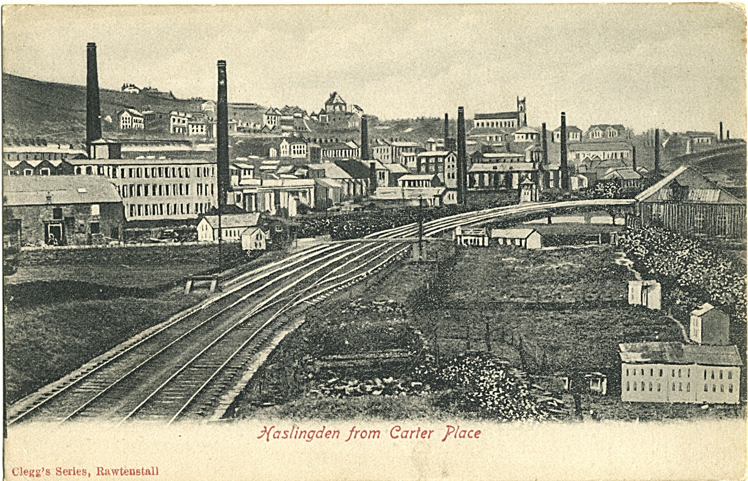
This is a very old postcard and does show Station Steps, Railway Road with its small grocers shop at the bottom, and the "Northern Window Lights" of the Haslingden Commercial Mill Co. and the start to the approach road to the Haslingden Station. By the way the tall building standing proud to the back was the old Baxters (Lower Lane) Brewery. Postcard: author unknown/archive
(Below) Road leading down to Commerce Street, Carrs (Junction 3)
Photo shows the old Paghouse Mill and the road Commerce St leading to Carrs.
(Below) Bridge Street (or Donkey Row) (Junction 4)
This is a great photo showing a before and after (approx) with the top photo shows the old Station area, but specially to see the greenhouses placed right on top of North Hag with trains going past deep below the greenhouses.
Photo: Kindly shared to us by Chris Kirby
Houses on Donkey Row (Bridge Street)Photo: thanks to Chris Kirby
Houses on Donkey Row (Bridge Street)
Photo: thanks to David Belshaw
The bottom photo is superb and gives a clear indication to how things looked as I remember in the 60s. From the photo you should recognize, Railway and Station Roads, the Haslingen Commercial Mill, Delph St, Bridge Street and the Railway yard with its timber boundaries. Of special interest is the showing of the two variant levels between one Donkey Row (Bridge Street) and also the lower levelled Station approach Road. Obviously a great photo of the old Station as well.
Photos: kindly shared (top photo) Chris Kirby and (bottom photo) by David Belshaw.
(below: Station approach service road (Junction 5)
Here is a fabulous photo of which we refer above to Junction No.5 which shows the approach service road to the station which was very wide for the amount of traffic that used it, and beautifully laid out dressed shoddies or "SETTS"
Photo: author unknown/archive
So now we proceed along Booth Street
(below) Booth Steet (Junction 6)
Booth Street
(Photo: thanks to Ray Whittaker)
Another photo of Booth Street from the opposite side and shows a little of the old Railway pub and across the way shows the on end sleepers used to fence off the Station Yard Photo: Derek Woodhall
This is Booth Street (top photo) which had a opening half way along on its right hand side and which you can make out in the photo (service area to reach the backs). At the forefront were the photo starts from is at the bottom of Delph Street. Although you cannot see in this photo the left hand side was the boundary for the Station Yard and this was made up with railway sleepers placed on edge with the tops cut back to a a sort of half diamond shape. If you followed this street along you ended up at the old pub called the Railway which is just out of view at the far end of this photo.
(Photo: thanks to Ray Whittaker)
So now you have reached the end of Booth Street and you would see the opening to the Station Yard and the old sidings Road, whilst on the other side of the road you would have seen the Railway Hotel and Station Road which led up to Blackburn Road.
Station Yard, and sidings, which you got entry from the bottom of Station Road and led off to your left at the end of Booth Rd (opp Railway Hotel).
Railway Sidings Road (Was situated at the end of Booth Rd, close to the old Railway Hotel at the bottom of Station Road corner. This road which was a wide cobbled road for most of its distance (although which became tarmacked a couple of hundred yards before you met the exit which came out at Carr Hall Street (off Hud Hey Road). On the way you would pass Brittania Mill on your right. I do feel out of respect I should mention my house which can be seen in this photo on Hud Hey Road to the LH of the trees. Sadly our house along with many others were demolished to make way for the by-pass construction.
Photo: thanks to Ray Whittaker
This photo shows the Railway sidings road which went from Booth Street (Station End) and all the way through to Carr Hall Street (off Hud Hey). Years ago all the coal trucks would have been seen all along the sides of this road. To the left of the forefront was the Station Yard and its old warehousing sheds etc. Just a little bit further on to your right and out of the view of the photograph was the entrance to what was known as Robinsons Yard and in there were a couple of stone built cottage houses, in fact you can from this photo see some remains of the houses in rubble or forming the boundary walls.
We are continuing passed the bottom of Station Road passing the mills, Vine Mill and were Robinsons Mill stood
Station Road
(above) Here is a vintage photo showing Station Road with the old cobbled setts, you can see the Railway pub on the right hand side. Also you see a little girl standing at the left and just by the entrance to the Railway sidings road as shown in the photo above. (Photo: author unknown/archive)
(above) is a more recent photo of part of Station Road
on a Wintry day. That caravan was there for many years.
photo: thanks to Ray Whittaker
Station Road just before demolition, and also shows the start of Cross Street South with car.
Photo: Thanks to Colin Griffiths
This photo above shows the view in more recent times, looking down Station Road from Blackburn Road. Most of the Station Road properties are now gone.Photo: B. Yorke
Crossing over from Booth Street and passing the old Railway Hotel which was on the corner with both Booth Street and Station Road, you then pass the Mill which I remember has Vine Fabrics (Candlewick bedspread manufacturers) and then there was a small gap before you reached the next mill which was Wm. Robinson and Co. Union Mill (Greycloth cotton manufacturers (see photos below).
This mill was formerly Vine Fabrics (Vine Mill) and was and still is at the very bottom of Station Road and was on the opposite corner to the Railway Hotel.
The next mill was Robinsons, Union Mill which is shown in the next photo.
shows Vale Street, Wm Robinsons Mill on Barnes St and Vine Mill to bottom right
the photo was taken in 1976.
Photo: thanks to Chris Kirby for this fantastic photo
This is the building now built on the site of the Wm Robinsons Mill which got ravished with fire and had to be demolished. The road you see here used to be a thoroughfare which lead on to Cross Street South and it was called BARNES STREET. To the top right hand side of Barnes St were some nice buildings which were the Robinsons Mill offices and next to them were the workshop were I worked on building maintanance at one time.
Straight after passing the Vine Mill and old Robinsons Mill/Barnes St we came to
Vale Street which had a row of terraced properties - see next photo.
But also across the road and just before Vale Street there was the cobbled road which ran out to the old Anderton and Halsteads Mill on the right hand side. I think this mill in more recent times was owned by Winfields for their storage. Also this was the entry to get to the CWS Slipper Factory (Brittania Mill), and also another business down there called W. Kays Engineering.
So we have gone passed Station Road, the Mills and now proceed up Vale Street and on to Cross Street South.
Vale Street
Vale Street
Photo: thanks to Colin Griffiths
Vale Street was only about 60 yards in length before you came to Cross Street South and if you then turned right into Cross St it would after some 150 yards bring you on to Station Road of which you could turn left for abour 50 yards before coming back on to Blackburn Road (about 50 yards from Station Steps were we began our virtual trip)
We have now turned right onto Cross Street South and turn left at the end into the top side of Station Road
Cross Street South
Another area were the properties have gone missing is Cross Street South. Thankfully Chris Kirby has found this old photo below in his dads collection and we are also lucky to find a photo showing the backs of the properties of which we are so thankful to Derek Woodhall.
Another fabulous photo of the old Cross Street South showing the low terraces at this end and further along there were two or three houses built higher which you got access by steps if I remember.
Photo: thanks to Chris Kirby for sharing with us.
Shows the backs of Cross Street South
Photo: thanks to Derek Woodhall
Entering Station Road we turn left up to Blackburn Road
Thanks to several kind contributions we have been able to make up this virtual tour of the old Station area - starting from Station Steps and arriving back on Blackburn Road.
We are indebted to the following for photos and help: Charles Ashworth, David Belshaw, Colin Griffiths, Jackie, Chris Kirby, Henry Ross, Ray Whittaker, Derek Woodhall, and to the unknown photographers which we have used from within the archive.
And now we enter the
Railway Blog
Train entering Haslingden Station after coming through the North Hag Tunnel
(Painting by the late Mr. Arthur Kirby)
Please click over the painting to enlarge
This photo above shows Haslingden Station in the 1950s with train No. 42785 approaching the station having just come through North Hag Tunnel
and you can just see the start of Donkey Row (Bridge Street) to the right.
Photo: Arthur Kirby
This old postcard shows Station Steps, in the foreground is the old Commercial Mill,
and the little shop on the corner of what was Railway Road (or Pag House Lane),
You can see the old newsagents shop midway and the tall building to the back
of the postcard was the old Baxters Brewery which was on Lower Lane
This seems a very antiquated etching with strange resemblance eg: the
headers of North Hag shown on Bridge Street
This is a photo taken from up on Donkey Row (Bridge Street) looking down on the Station and it's goods yards and sheds and other buildings.
I can remember the British Railways Truck in its dark red and county cream livery, it was a Scammell 3 wheeler with a flat trailer. Here above is a picture of one which I took at last years Tram Sunday at Fleetwood... I would see one identical to this up and down that cobbled road, on a daily basis...
The main approach to the Station was via a wide cobbled road made up of highly polished setts, and the road swung round in a mighty arc (see photo above). On your approach and to your right was the Station yard which was solidly enclosed with side by side timber railway sleepers stood on end with pointed tops.
This is another photo showing from that wide cobbled approach
(see previous photo), here it shows a party of children awaiting their
day out on the train. There must have been this large boarding
with all the adverts of the day which included, Bass, Bovril, Althams Teas
This photo may well have been from around a similar time period as the one previous
This is the "Fresh Air Fund Trip" from Haslingden Station.
I remember, all the lights on the station platforms where gas lit, there where waiting rooms and toilets on both platforms. I also remember there was always a mass of timetables for various destinations throughout Lancashire, these seemed to always be neatly set out in a timber framed mount which had lots of little shelf pockets to house these timetables.... The station was generally manned by a staff of 2 or 3, I think it was one or two porters and the Station Master..
Every weekday a shunter train would come to the Haslingden sidings, usually it would be a very old looking heavy duty train of the WD Class numbered in the 90000 ranges or it would be a 3 or 4F type... They would come up mainly to shunt the W.H. Shaw coal wagons about, bring new filled up coal wagons from the pits of Lancashire and Yorkshire and would take away the empties, they would spend up to 4 hours a day working within the sidings.
I loved it during the school holidays when occasionally I would go along to the Station and try and help out, or probably get in the way, or now and again the drivers of the shunters would shout down and ask if I wanted to climb the footplate and drive the train down the track a little, they where great times and times that have created great memories for me.

The regular service trains that came through Haslingden where coming from Manchester and going to Colne (or the other way!), and the next stop on from here was the Baxenden Station and goods yard (which was just a little further on than the Hollands Pies factory near Rising Bridge) and then it was onward and downward to Accrington, then on via Rosegrove, Burnley, etc to Colne. Usually on this route where local "stanier" class trains which where in the main shedded at Accrington or Rosegrove... but besides these regular service trains, there would also be goods trains, and special excursions, especially for the wakes weeks annual "cotton towns" holiday fortnight...

This is a nice photo I obtained which shows steam still coming from the
North Hag tunnel, where the double header steam train is by now
approaching the signal box, just a hundred yards before the
Carr Hall Street crossing. Obviously its one of the last photos
when Haslingden Station had already finished, the waiting rooms on
the left hand side platform had already gone!
(Click over photos to enlarge) Above is a litho print photo of the old bridge on Hud Hey Road, it was in part cased in with
deep metal with a interesting triangular post which mentioned on it as far as I can
remember unladen weights etc....You can see the railway track side of the
bridge in the next photo below...
I like many others in the 50s was a train spotter armed with my Ian Allen book together with shed book which those days cost 10/6d (thats ten shillings and sixpence), and from where I lived at 110 Hud Hey Road, it was great. I could see the trains come into the Station or through North Hag Tunnel, watching from my back window and then nip out the front door and watch them from close range coming under the bridge at Hud Hey (see picture here on left). Sometimes there would be "namers" usually "Jubilee or Patriot" Classes. Sometimes you would see "double-headers" with many carraiges behind them.... they where really great times...... The famous photo above was the view I would see everyday from my back window at Hud Hey. The photo was taken on 3rd July 1964 by the late Mr. Eric Bentley
The Haslingden "Signal Box" was about 250 yards North of Haslingden Station on the same side and almost in line with Martincroft Farm which was to West, and also it was almost in line with Carr Mill which lie to its East. Another 100 yards further on was the level crossing which was accessed from Carr Hall Street or the Old Laundry and Martincroft on the other side... (there is still a crossing at this point for pedestrians to cross the local by-pass)
And here are two very old photos of Helmshore Station.. but first is a more recent (1966s) photo showing a double header passing Prinny Hill. The photo taken by the late Eric Bentley..

I am currently working on a small section here
which will depict the final stages of the Station
and its buildings and the actual track etc
after the railway had ceased as a railway
and everything was sadly deteriating and
awaiting demolition etc
These are the old Goods Shed close to the Haslingden Station.
The photos were being offered for sale on Ebay These are the old Goods Shed close to the Haslingden Station.
The photos were being offered for sale on Ebay
These are the old Goods Shed close to the Haslingden Station.
The photos were being offered for sale on Ebay
This shows the last photos before the sad destruction of the North Hag Tunnel.Here was the stretch that ran past St. James and St. Marys Football Groundson approach to the "North Hag Tunnel"(Photographer: unknown) Here is a old photo taken from within North Hag Tunnel looking out and showingCWS Brittania Mill with first chimney and in the far background it lookslike Clough End Mill (Hud Hey Road)Photographer: unknown Sadly the last photos showing the cutting through of North Hag,with Hutch Bank Quarry in the near backgroundPhotographer: unknownSadly another one showing the final stages of the removal of the North Hag Tunnel
at Bridge Street (Donkey Row)
Photographer: unknown
This is before and after photo created by the late Arthur Kirby
It shows the area which was the old Railway station towards Hud Hey
The top photo is around the 1960 and the bottom photo is 1993
Thanks to Chris Kirby for sharing with us.


(Photo: Jean Tomlinson)
This photo is something really special to actually see the old Grane Road Signal Box
Thanks Jackie Ramsbottom for sharing with us.
Below are photos from the Last Train event before the closure from Helmshore Station - Bury to Accrington 1966
Photos of people at Helmshore Station on the event of the very last train before the closure of the line back in 1966 (Bury to Accringtion)
Photo: Thanks to the estate of the late Garth Dawson
Photos of people at Helmshore Station on the event of the very last train before the closure of the line back in 1966 (Bury to Accringtion)
Photo: Thanks to the estate of the late Garth Dawson
Photos of people at Helmshore Station on the event of the very last train before the closure of the line back in 1966 (Bury to Accringtion)
Photo: Thanks to the estate of the late Garth Dawson
Photos of people at Helmshore Station on the event of the very last train before the closure of the line back in 1966 (Bury to Accringtion)Photo: Thanks to the estate of the late Garth Dawson
Photos of people at Helmshore Station on the event of the very last train before the closure of the line back in 1966 (Bury to Accringtion)
Photo: Thanks to the estate of the late Garth Dawson
Photos of people at Helmshore Station on the event of the very last train before the closure of the line back in 1966 (Bury to Accringtion)
Photo: Thanks to the estate of the late Garth Dawson
Photos of people at Helmshore Station on the event of the very last train before the closure of the line back in 1966 (Bury to Accringtion)
Photo: Thanks to the estate of the late Garth Dawson
Photos of people at Helmshore Station on the event of the very last train before the closure of the line back in 1966 (Bury to Accringtion)
Photo: Thanks to the estate of the late Garth Dawson
Photos of people at Helmshore Station on the event of the very last train before the closure of the line back in 1966 (Bury to Accringtion)Photo: Thanks to the estate of the late Garth Dawson
Photos of people at Helmshore Station on the event of the very last train before the closure of the line back in 1966 (Bury to Accringtion)
Photo: Thanks to the estate of the late Garth Dawson
Photos of people at Helmshore Station on the event of the very last train before the closure of the line back in 1966 (Bury to Accringtion)Photo: Thanks to the estate of the late Garth Dawson
(Received Email from Joan B on 12th April 2014)
We then moved on to Rising Bridge and were friends with Alan and Margaret Birtwistle and their children who took over the butcher's. Their son is now a surgeon.
Margaret's brother,Gordon Dakin,my husband and other friends knocked down part of Haslingden railway station building and used the stones as foundations for houses that were being built at Baxenden.
Regards, Joan B.
Yes you did have us “beat” with that one Mr. Chin - g!
And now 50 years are passing this week!
I guess you felt it right on the day for us, and other days for them,
Maybe you thought not enough folk travelled on it to Bury or Manchester,
Or maybe tuther way to Baxenden, Accrington, Burnley and Cowne.
Wakes trains were always full and steamed from under North Hag or (bonk!)
And Donkey Row was completely fogged owt!
Not Now!
And now 50 years are passing this week!
We’ve still got our “arches” down at Shore dear Sir,
And now we do have Ravens crossing its many bows,
And we’ve still got our memories of chugging (rather than buzzing!)
And the delightful (in its own way) smells of steam,
And fifteen years on in 1981 a “By Pass” shall be built,
Just where that very Stations weeps!
28th November 2016