
Here is a photo which I took back in 2008 showing the ruins of "Priestentax" to the forefront of the third tree on the right, the area which lies on the southern
flank of the Haslingden Moor near to the ancient (track) road which led over the Haslingden moor towards Oswaldtwistle.
These days Priestentax ruins can be accessed from the quarry road (in part) which runs by the side of "Virgins Row" on one side and the waterboard houses on the other side, and continuing up the quarry road for a short while before picking up the ancient track on the right hand side which later has "Troy Quarry" on its right hand side (over the quarry spoils), before eventually reaching Priestentax. (see photo above and below - showing the old track)
What always intrigued me so much are the fabulous names of these old "hamlets" and from a early age whilst accessing the moor to lead me over to Thirteen Stone Hill, I often queried in my mind what were the origins of the fabulous name and what did it mean.
 Priestentax
Photo: Kindly Shared by Geraldine Simister
 Priestentax
Photo: Kindly Shared by Geraldine Simister
 Priestentax
Photo: Kindly Shared by Geraldine Simister
What always intrigued me so much are the fabulous names of these old "hamlets" and from a early age whilst accessing the moor to lead me over to Thirteen Stone Hill, I often queried in my mind what were the origins of the fabulous name and what did it mean.

Photo: Kindly Shared by Geraldine Simister

Photo: Kindly Shared by Geraldine Simister

Photo: Kindly Shared by Geraldine Simister

Priestentax
Photo: Kindly shared by Angela Neild

Priestentax
The name Priestentax probably means "Priest intake" or of a person of that very name (Priest), who originally took the land from the nearby Haslingden moor to form the farm settlement.
First record we have about Priestentax is from 1626
A record of a baptism at St. James Church on 28th January 1626 of Alice daughter of George Lange de Priest Intakes. (Alice f. Georgii Lange de Priest Intakes). It is very likely that George Lange was the first owner or tenant at Priestentax.
We have a record from prior 1777 to 1790 and later
Notes from Andrew Neil Taylor (2019) - Priestentax was the home of Henry and Mary Hayhurst. Henry died there on 28th July 1777, Mary on the 3th November 1790, their son James then took over, I am awaiting the rest of the family tree to find when the family left Priestentax
We have a record from 6th August 1794 to 23 August 1797
A record shows of a baptism on 6th August 1794 of Nancy daughter of James Betty of Priestentax. A further record shows of the death of Nancy on 23rd August 1797.
We have a record from prior 1881 to 1887 and later
Notes from Geraldine Simister (2019) - 1881 census my Great great grandfather, James Wrathall lived there with his 2nd wife, 2 children and his elderly father, William - he moved there from the Hawes area in Yorkshire - I've often wondered how and why he came to be living there. It must have been rather cramped! My grandmother was also born there in 1887 and was christened at the Methodist chapel over Grane. She was Jane Elizabeth Wrathall, married name Kaine. It would be great to have some idea of what the farm looked like.
We have the 1911 census (below) for Priestentax
A George Metcalfe Parker and his family lived there in 1911.

Please click over the census to enlarge
We also have a later record from Priestentax
A memorial card exist for Mathilde Kirstine, the beloved wife of David Downham of Priestentax Farm, Grane who died December 7th 1920 and was interred at St. Stephens Church.
We have now been fortunate to have located a further document which gives even more details of that original building. It does mention that the report is reflecting on how the property may have shown during the period: pre-1798
Condition - slighted ruin
From much later map evidence eg: 1893 OS 1:2500. It shows the farm Priestentax consisted of - Two buildings and outbuildings enclosed in a large farmyard; one is two conjoined buildings, one with an internal division, forming irregular rectangle with appendages 75'x35/25', probably farmhouse and cottage; and the other a rectangular barn of 70'x50'.
The document goes on to show Field Evidence - which shows a Grass covered ruin, outline of residual walls of buildings discernible. Two main buildings identified - house and barn. Behind barn is a constructed stone trough, and to the E of it a solid one.
All buildings are free-standing. The tree marked on 1893 OS still survives. The Rossendale Way follows the land leading from Heap Clough and enters the farmyard via a stile. It passes the front of the house and round the barn.
The site enjoys a commanding view of the Grane valley ranging from Musbury to uglow Pike, with Grane Head clearly visibly. Before quarrying the farm, at the head of the clough, would have overlooked its arable fields, meadows and pastures on the wide sweep of the terrace below.
These terraces, which occur throughout the local Pennines were primary settlement areas in prehistoric times. The site of Priestentax may have its origin in those times, therefore, potentially it is of archaeological importance.
Comment: As the site has been allowed to decay naturally and there is no evidence of stone robbing. The site should be protected and left strictly alone. It would well re-pay a detailed archaeological investigation from many points of view; the antiquity of the site, building history and details of interior features and organisation.
The investigation should include foundation and sub-soil investigations to test for early settlement evidence of prehistoric times. The topographical position of the site suggest it is of greater antiquity than a mediaeval priest's intake.
FAR PRIESTENTAX

Above shows two photographs of the Far Priestentax ruins which I took back in 2004


Photo: Kindly shared to us by Brian Smith

Photo: thanks to Angela Neild
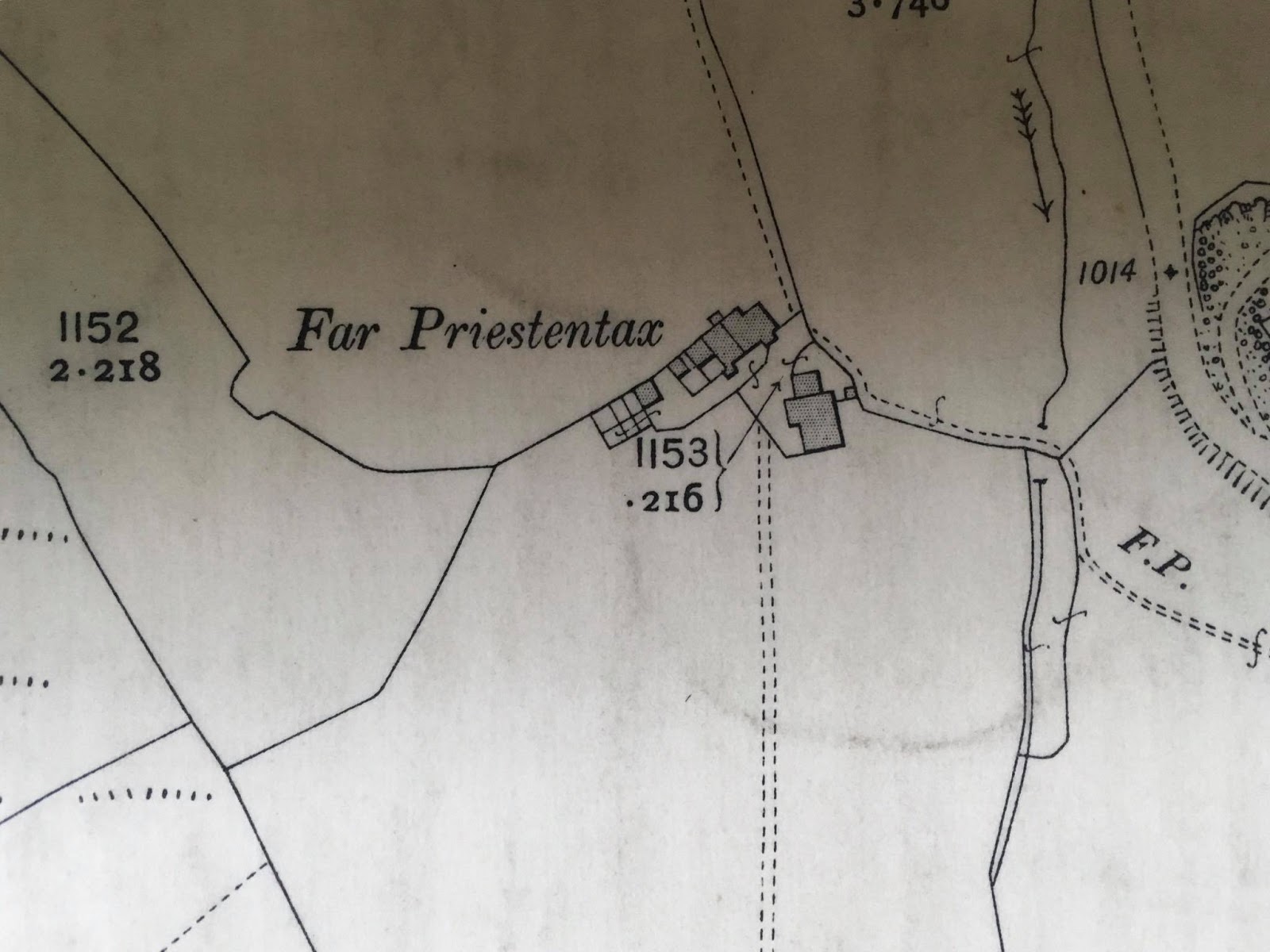
 Showing the original Far Priestentax settlement on this old map
Period: pre-1798 and probably 17th century, it's condition was recorded as a - standing ruin
Map Evidence: 1893 OS 1:2500. Shows two buildings: 1) linear building with appendages 90'x35' and 2) an L- shaped building 50'x40/30'. South facing with access down track towards Troy and Heap Clough
Documentary Evidence: The name "Priestentax" is an unusual one which has given rise to local explanations of the origin; none of which can be confirmed. The earliest spelling encountered is "Priesting Tax" (1798 Poor Rate Survey). However, the explanation that it signifies intake land for the use of the priest of Haslingden Church is a possible one, reflecting early enclosure of the common land on Haslingden Moor.
Three entries occur in the 1798 Poor Rate Survey under the name "Priesting Tax" one of over 13 acres, another over 29 acres and the third, over 11 acres (cstm). However, only two are identified on the map - "Far Priestentax" and "Priestentax". The most likely explanation of the missing No.3 is that one of the above-named farms was a double one in 1798.
It seems that the one listed No.44 in the 1798 Poor Rate Survey refers to the site under description. It lists a farmhouse, barn and outbuildings - apparently in a bad condition; three cottages and over 29 acres of land (cstum). This description appears to be supported by available field evidence.
Field Evidence: The site appears to have naturally decayed with very little robbing. Building 1) is a back to earth house or cottages with adjoining farm building. A small 19th century type dairy extends at the rare in the E-end cottage. A door lintel with carved initials "GH" has been propped up by the entrance of this small dairy. Building 2) is a typical hillslope barn with shippon beneath.
The stonework is mixed flag and gritstone and many of the residual walls are standing to a height of about 6'. Massive gritstone quoins are present in what appears to be a secondary position, suggesting re-use of earlier building materials from a more substantial house.
Pedestrian access only, although vehicular access (4WD) is possible across the pasture from the moor-gate at the head of the track leading up from Heap Clough.
Thanks also to Jackie Ramsbottom for lots of the factual information and also John Simpson, Andrew Neil Taylor, and Geraldine Simister, Angela Neild, and Brian Smith for help with text or photos.